
Tatshenshini River Rafting
Rafting Down the River
"May all those who care so much about wilderness that they are willing to take a stand to ensure its preservation, and to future generations. May they, like us, always have the chance to experience Tatshenshini Wild" --John Schnell
Why Choose CRATE?
- Under Original Ownership Since 1971
- 5 Star Rated Rafting Trips
- We Provide Everything You Need For a Great Rafting Trip
Book Your Adventure Today!
(800) 253-7328
Home » Rafting Down the River with CRATE » Tatshenshini River Rafting
Rafting the Tatshenshini River through Canada and Alaska
The Tatshenshini River is an emblem of untrammeled places and the majesty of wilderness. The river flows through the Yukon, British Columbia, and Alaska on its way to the Pacific Ocean. It is renowned for its pristine wilderness, rich ecosystems, and cultural importance.
“The Tatshenshini River is a rolling sluice of mountain water that scrawls its signature across the rugged landscape of British Columbia’s northwestern corner. From its interior headwaters, the river runs a ragged course, twisting and bucking its way through the bullying, glaciated thrust of the St. Elias Mountains, sweeping past some of North America’s largest ice fields and, after a meander through Glacier Bay National Park, finally exhausted, it debouches into the Gulf of Alaska, 200 miles distant. Spirited in itself, Tatshenshini traverses as remote a corner as can be found on the continent, a place of such primal intensity and unvarnished beauty as to define the word wilderness.”-Rick Searles
Tatshenshini River–Must be Experienced to be Believed
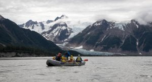
Rafting the Tatshenshini River with Colorado River and Trail Expeditions is as amazing as rafting the Grand Canyon– in a totally different setting. Many have said the Tatshenshini River is the most visually exciting landscape in the world. On this rafting trip, you will experience eagles soaring, grizzlies roaring, and glaciers reaching close to the river’s edge. As the river grows from a small alpine stream to a major waterway of great proportions, so too grows the landscape, until in the final days, 15,000-foot snow capped peaks encircle the horizon.
Incredible Biological and Geological diversity along the Tatshenshini River
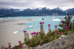
 Traveling by river is the only way to see and experience the incredible biological and geographical diversity that exists within the Tatshenshini-Alsek wilderness area. From the alder and aspen forests of the Yukon, through the steep mountain valleys of British Columbia, to the ice fields of Alaska’s Glacier Bay, the river sweeps through landscapes of wondrous size and design.
Tatshenshini River–An Overview
Geography and Location
- Source: The Tatshenshini River originates in Western Canada near the border of British Columbia and the Yukon. Our Tatshenshini Rafting trips start at Dalton Post, once a trading post, it holds significant historical and cultural importance for the region.
- Course: The river flows south and west from Dalton Post, winding through a remote and eco-diverse region before emptying into the Alsek River. From their confluence the Alsek continues through the coastal St. Elias Mountain Range before emptying into the Gulf of Alaska and the Pacific Ocean.
- Length: The Tatshenshini-Alsek River flows approximately 130 miles from Dalton Post to Dry Bay.
Ecology and Environment
- The river flows through a spectacular landscape of glaciers, alpine meadows, temperate rainforests, and wetlands.
- The Tatshenshini-Alsek Wilderness Area is a major ecological region encompassing the river and its surrounding lands. The Tatshenshini and Alsek Rivers have their headwaters in the extremely rugged regions of Northwest British Columbia and Yukon. Their corridors and tributaries connect a vast wilderness composed of adjoining parks and preserves in the United States and Canada that covers more than 60,000 square miles. This is the largest protected ecological unit in the world. It contains the largest non-polar ice field in the world, the highest coastal mountain range in the world, and the only completely protected large river drainage system in North America. This wilderness area is home to a variety of wildlife, including grizzly bears, black bears, wolves, moose, and a rich diversity of birds and fish.
In recognition of its extraordinary scenic and wildlife values, the Tatshenshini-Alsek area has been designated a World Heritage Site by the United Nations. It is one of the “must see” places of the world, where pristine nature still exists to excite the imagination and nourish the spirit.
Cultural Significance
- The Tatshenshini River has deep cultural and historical importance for Indigenous peoples, particularly the Tlingit, Tutchone, and Kluane First Nations, who have lived in the region for thousands of years. The river was used for travel, fishing, and as a source of food and materials.
- The region is still important for these communities, who have historically relied on the river for subsistence and trade.
Wilderness and Conservation
- The river and its surrounding wilderness are part of the Tatshenshini-Alsek Provincial Park in British Columbia. These protected areas are jointly managed by Canadian provincial and territorial governments.
- The Tatshenshini-Alsek Wilderness Area was designated as a UNESCO World Heritage Site in 1994, recognized for its remarkable natural beauty and ecological significance.
- The area is considered one of the last pristine wilderness areas in North America and is a prime location for eco-tourism and wilderness adventure activities, such as kayaking, rafting, and hiking.
Recreational and Tourism Activities
- The Tatshenshini River is a popular destination for white-water rafting and kayaking, especially for those seeking an adventurous and remote wilderness experience.
- The stunning landscapes along the river, with towering glaciers and dramatic mountain views, attract nature photographers, hikers, and wildlife enthusiasts.
Hydrology
- The Tatshenshini River is fed by snowmelt and glaciers, meaning its flow can vary significantly, especially during the warmer months when snow and glacial melt increases the river’s volume.
Environmental Threats
- As with many remote rivers, the Tatshenshini River has and will continue to face threats from potential industrial development, including mining and hydroelectric projects. There have been concerns about the potential impact of such developments on the local ecosystems and wildlife.
Tatshenshini River Trip Highlights
Traveling by river is the only way to see and experience the incredible biological and geographical diversity that exists within the Tatshenshini-Alsek wilderness area. From the alder and aspen forests of the Yukon, through the steep mountain valleys of British Columbia, to the ice fields of Alaska’s Glacier Bay, the river sweeps through landscapes of wondrous size and design.
Tatshenshini River Rapids-The Canyon Section
The first day of our expedition down the Tatshenshini River we drive from our warehouse in Haines, Alaska to the put in at Dalton’s Post, Canada. Dalton’s Post was active in the late 1800s and was located on one of the routes to the Yukon gold fields. Shortly after leaving Dalton Post the river picks up speed and enters a narrow canyon. We fit everyone with drysuits for this section of the Tatshenshini River. The canyon is usually class III, but at higher water levels can become IV+. Soon the narrow canyon widens and the river mellows. The first nights camp is found at or near Silver Creek.
Hiking Goat Ridge From Sediments Creek
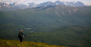
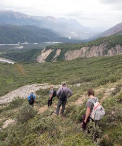
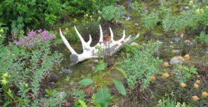
One of the best hikes of the rafting trip is Goat Ridge. The hike is accessed from Sediment Creek and gains elevation quickly. Once on top of the ridge hikers get a great view of the river down below, and get a chance of capturing a glimpse of a Mountain Goat in its natural habitat. Bears and fox are also routinely seen along the route.
The Windy Craggy Mine and Monkey Wrench Rapid
 In the 1950s, a small copper rich mountain was discovered by helicopter near where the O’Connor River joins the Tatshenshini River. This mountain was named Windy Craggy. Because of the remoteness of the mountain, nothing happened until the 1980s when a company from British Columbia obtained some interest in the mine by agreeing to pay for the exploration of the mountain. Windy Craggy is rich in Copper, with an estimated value of around 10 billion dollars. The mine would have been a huge open pit mine with roads and bridges criss-crossing the Tatshenshini River and its tributaries. Luckily the environmental impacts from the mine far outweighed the value in dollars and cents. On June 22, 1993, B.C. Premier Mike Harcourt created the Tatshenshini-Alsek Park. In addition, in 1994 UNESCO/IUCN added the park to their World Heritage List. The park became an extension of the pre-existing Kluane National Park/Wrangell-St. Elias National Park and Reserve and Glacier Bay National Park World Heritage Site.
Around 1990 a large flash flood created a new rapid on the Tatshenshini River. The new rapid was located at the proposed site of a bridge in conjunction with the Windy Craggy mine. The rapid was named “Monkey Wrench,” as an outcry to stop the building of the Windy Craggy Mine. Today it is a reminder about what could have been.
The O’Connor River to the confluence with the Alsek River
 The Tatshenshini River nearly doubles in volume with the addition of the O’Connor River and the Tkope River. The river becomes wide and braided. Melt Creek enters on river right shortly before the Tatshenshini’s confluence with the Alsek. Melt Creek has beautiful blue water and again almost doubles the volume of the Tatshenshini. At this point the river valleys are wide and the scenery is incredible.
Welcome to Alaska and Glacier Bay National Park
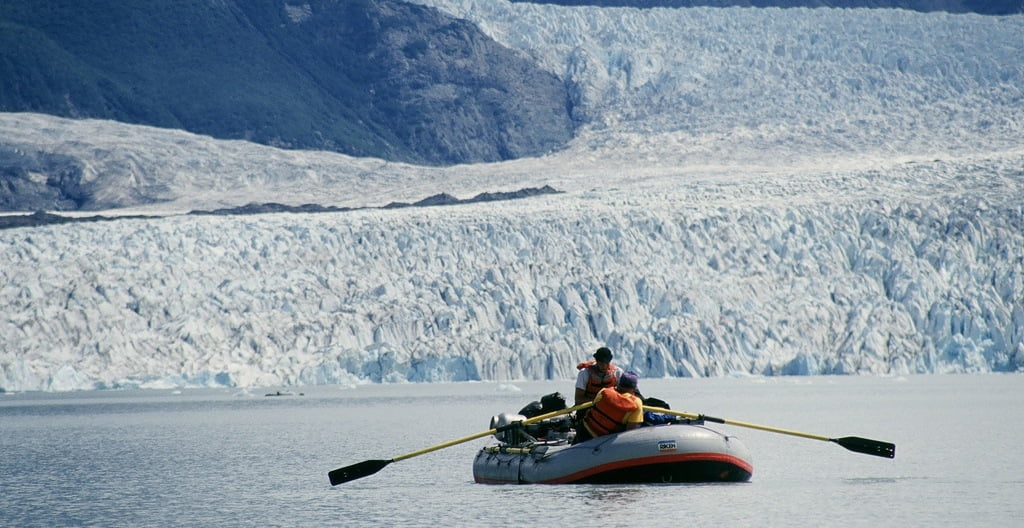
 Shortly below the confluence, the Alsek leaves Canada and enters the United States and Glacier Bay National Park. The Walker Glacier, until recently, was easy to access and hike on. It has been greatly affected by global warming during the time we have operated on the Tatshenshini River. On our first trip in 1978, the glacier was only a few hundred yards from the river channel. Now the glacier is set back thousands of feet from the river and almost inaccessible due to the enormous lake it has carved out and treacherous glacial moraine deposited along the glaciers edge for hundreds of years.
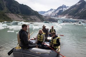
Alsek Lake and Mount Fairweather
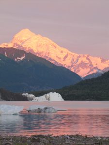 If the weather is clear, 15, 325 foot Mount Fairweather will be visible. The peak of the summit is only 12 miles from the Pacific Ocean. The mountain adds an incredible backdrop to the already stunning landscape of the Alsek River. The Alsek flows into Alsek Lake which has been created by the recession of the Alsek Glacier. The camping along Alsek Lake is some of the best of the trip. There are hundreds of icebergs floating in the lake. Some of these icebergs jut over 100 feet out of the water. About 90% of an icebergs mass is underwater. As the ice underwater melts it changes the icebergs center of gravity and it rolls over. Sometimes the icebergs roll over because a big piece of them breaks off. Sometimes the entire lake is calm and still. Then there will be this huge crack and splash. With time, the edge of camp is blanketed with waves form the iceberg rolling or breaking, that lap at the shore.
Dry Bay Take-Out
 From Alsek Lake to the take-out at Dry Bay is less than 15 miles. We are not allowed to camp at Dry Bay. Depending on our flight time, the last morning can be an early one. After a quick breakfast and loading of the rafts we will float the remainder of the trip along Barbazon Mountain Range towards the Pacific Ocean. Once at Dry Bay, the rafts will be disassembled and packed into the airplanes for the return trip to Haines. Guest are generally taken to Yakutat, Alaska and then flown via jet back to Juneau.
Tatshenshini River Fun Facts
1. Home to One of North America’s Most Pristine Wilderness Areas
- The Tatshenshini River runs through the Tatshenshini-Alsek Provincial Park. The area is considered one of the best-preserved wilderness areas on the continent, attracting adventurers and conservationists alike.
2. Named After the Indigenous People
- The name “Tatshenshini” is believed to come from the Tlingit and Ahtna Indigenous languages. It roughly translates to “river with fish” or “river of many fish,” reflecting the river’s importance as a source of sustenance for Indigenous peoples for thousands of years.
3. The Alsek Glacier
- The Alsek Glacier, which is located below the confluence of the Tatshenshini and Alsek Rivers is a large glacier, spanning approximately 24 kilometers (15 miles) long and located in Glacier Bay National Park in Alaska. It’s notable for its significant size and the large glacial lake it feeds into, called Alsek Lake.
4. Glacial Flooding
- In the past the region has experienced glacial outburst floods (known as “jökulhlaups”), where sudden melting of glaciers can release enormous amounts of water. These floods can dramatically change the landscape.
5. A Paddler’s Paradise
- The Tatshenshini is often regarded as a “paddler’s paradise.” With its fast-moving, pristine waters, it offers a thrilling experience for rafters and kayakers.
6. Connection to the Alaskan Wilderness
- The Tatshenshini River forms part of the Alsek-Tatshenshini River System, which connects Canada’s wilderness with the Alaskan wilderness. It eventually feeds into the Gulf of Alaska through the Alsek River. This natural corridor has been essential for wildlife migration and, in some ways, for human migration in pre-Columbian times.
7. A Photographer’s Dream
- Due to its breathtaking landscapes—ranging from glaciers and rivers to towering mountain peaks—the Tatshenshini-Alsek area is a favorite for photographers. The shifting light, expansive vistas, and diverse ecosystems make it an ideal location for capturing stunning outdoor shots.
8. Extreme Weather
- The region experiences extreme weather conditions due to its proximity to coastal Alaska and the Pacific Ocean. This means that sudden storms, intense winds, and fluctuating temperatures are common, adding to the challenge for anyone planning an expedition in the area.
9. Rich Geological History
- The region around the Tatshenshini River contains unique geological formations, including ancient rock formations that are part of the Wrangell-St. Elias Mountains. These mountains are among the tallest in North America, and the area has been shaped by millennia of glacial activity and tectonic movements.
10. One of the World’s Largest Icefields
- The river is fed by glaciers that are part of one of the largest icefields in the world. The icefield spans both Canada and Alaska, contributing massive amounts of freshwater to the river system.
If you have any questions or to book a Tatshenshini Rafting adventure today please call us at (800) 253-7328.
Tatshenshini River Rafting Recommendations


Home » Rafting Down the River with CRATE » Tatshenshini River Rafting
CRATE Rafting Trips Since 1971
Free PDF copy of our Rafting Brochure!