

Alsek 12-Day Alaska Rafting Expedition

The best-organized trip I’ve ever taken. Our guides made every moment special.
Mary, Grand Canyon Expedition
Under Original Ownership Since 1971
5 Star Rated Rafting Trips
We Provide Everything You Need For a Great Rafting Trip
Overview
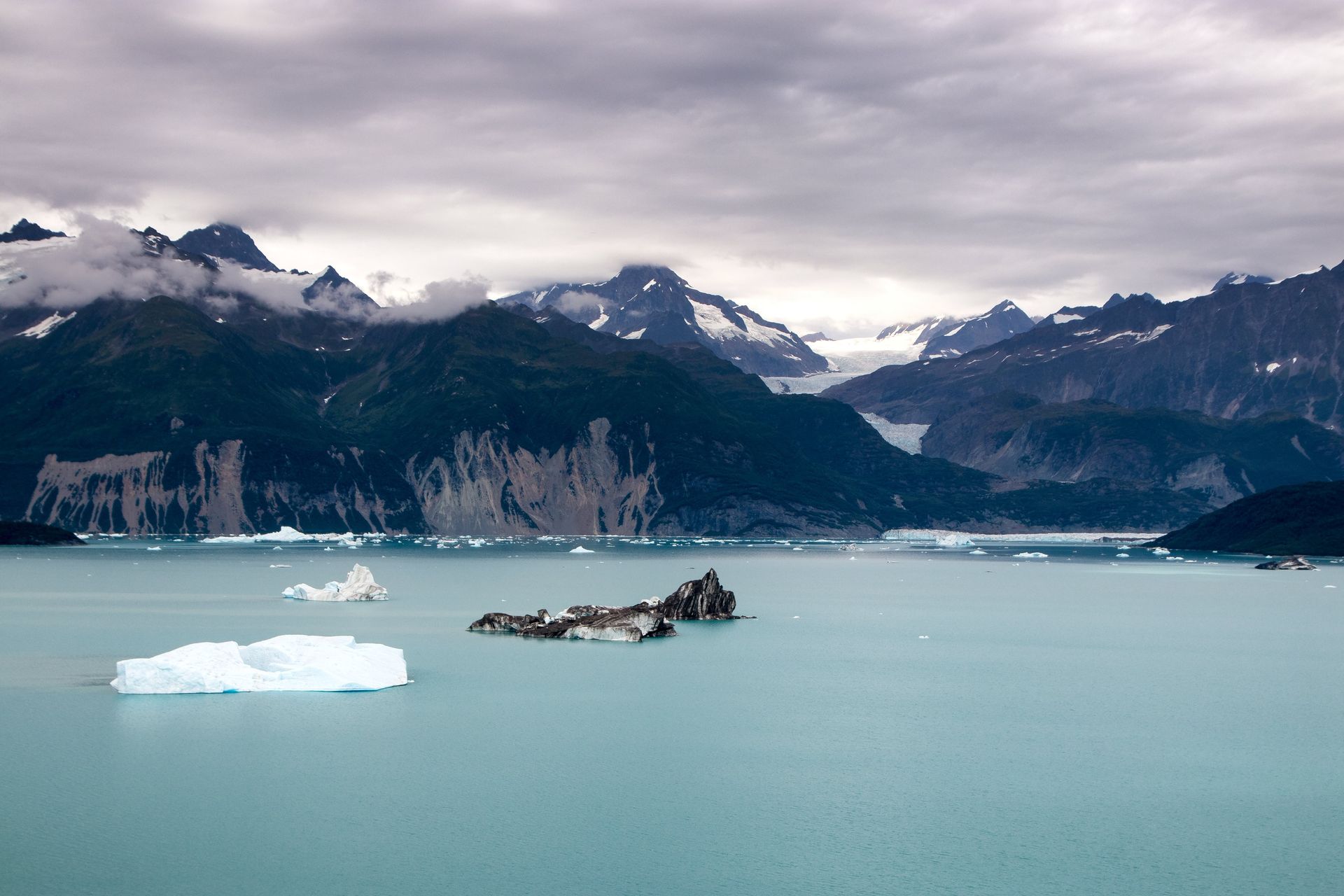
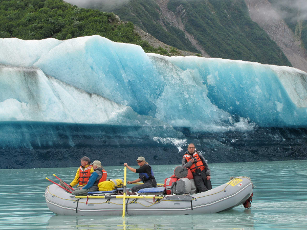
This 12-day expedition is a true "Far North" adventure, covering 174 miles through a landscape defined by advancing glaciers and ice-age geology. The journey begins in the open country of the Yukon before speeding up into Lowell Lake, where you will raft among floating icebergs and tackle the formidable Lava North rapid. A major highlight of the trip is the helicopter portage over the dangerous Turn Back Canyon, where the river is constricted by the surging Tweedsmuir Glacier. After the portage, the river widens at the confluence with the Tatshenshini, leading you past the massive Walker Glacier and into Alsek Lake, where you will spend a day rowing among beautiful icebergs. The trip concludes at Dry Bay with a bush flight to Yakutat followed by a connecting flight to Juneau.
Trip Details
Itinerary
Pre-trip evening (Haines, AK)
5:30 pm – Meet at the CRATE warehouse in Haines, Alaska for an orientation. You will receive your waterproof bags, get fitted for a dry suit, and have your passport information recorded to expedite the border crossing.
Day 1 – Travel to Serpentine Creek & Launch
Depart in the morning from the Haines warehouse by van or bus. You will travel to the put-in at Serpentine Creek, located in the Yukon Territory. After rigging the boats and receiving a safety orientation, you will launch onto the river and begin your journey downstream.
Days 2–11 – Glaciers, Rapids, and the Helicopter Portage
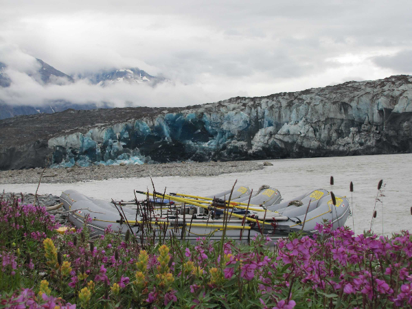
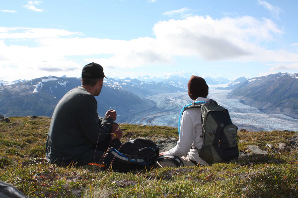
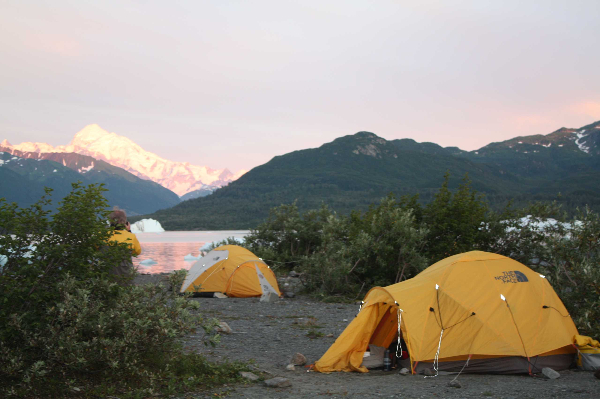
The expedition flows through a vast wilderness of glaciers and mountains. Key highlights include rafting among icebergs in Lowell Lake, running the formidable Lava North rapid, and a spectacular helicopter portage over the unrunnable Turnback Canyon. You will eventually reach the confluence with the Tatshenshini River, marvel at the beauty of the Walker Glacier, and row through the massive icebergs of Alsek Lake. Days are filled with wildlife viewing (grizzly bears, moose, wolves) and evenings are spent camping on gravel beaches.
Day 12 – Take-out at Dry Bay & Return to Juneau
The trip concludes at Dry Bay in Glacier Bay National Park. You will take a scenic bush flight to Yakutat, followed by an Alaska Airlines flight to Juneau, typically arriving in the evening.Includes
- Ground transportation from Haines, AK to the river put-in at Serpentine Creek
- Rafting 174 miles from Serpentine Creek to Dry Bay
- Helicopter portage for all guests and equipment over Turn Back Canyon
- Flights at the end of the trip: Bush flight from Dry Bay to Yakutat, AK, and Alaska Airlines flight from Yakutat to Juneau, AK
- Camping equipment: Sleeping bags, foam pads, ground cloths, tents, and plates/utensils
- Dry suits (Kokatat brand) to wear on the Lava North rapid day
- All meals on the river, beginning with lunch on the first day
- Assorted non-alcoholic beverages
- Souvenir 32 oz water bottle and 16 oz coffee mug
- Life jackets (Coast Guard approved)
- Waterproof bags for clothing and personal items
Excludes
- Lodging before or after the river trip
- Alcoholic beverages (participants may bring a small limited supply)
- Travel insurance (including emergency evacuation or trip cancellation)
- Gratuity for the guides
- Transportation to Haines, AK to begin the trip
What to Bring
- River clothing: Long underwear (polypropylene/capilene), quick-dry long pants and shirts, bathing suit, and breathable layers .
- Warm layer and rain gear: Fleece or wool jacket and pants, a synthetic "puffy" jacket, and a high-quality 2-piece rain suit (jacket and pants).
- Footwear: Rubber boots (like Xtra-Tufs) for the raft, light hiking boots or athletic shoes for camp, and sandals or neoprene booties.
- Sun protection: Hat with a brim and tie-down, sunglasses with a strap, sunscreen, and lip balm.
- Personal items: Toiletries, medications, insect repellent, passport, headlamp, and camera with extra batteries
Frequently Asked Questions
What rivers do you raft?
We run the Colorado River and Green River – including Grand Canyon, Cataract Canyon, Desolation Canyon, and Westwater Canyon – as well as the remote Tatshenshini & Alsek Rivers in Alaska.
Is there a minimum age requirement for your rafting trips?
Yes — the age requirement depends on the trip:
- Grand Canyon: 12 yrs (motorized) | 14-16 yrs (rowing/paddle)
- Cataract Canyon: 12-14 yrs (depending on flows)
- Desolation Canyon: 6-8 yrs (min weight 50 lbs)
- Westwater Canyon: 12-14 yrs (depending on flows)
- Alaska: 14-16 yrs (depending on flows)
- 1-Day Trips: 6-8 yrs (min weight 50–60 lbs)
What should I bring / how do I pack?
We provide most major gear (cots, sleeping bags, dry bags, etc.). We recommend lightweight, quick-drying clothing layers, rain gear, water shoes, and extra camera batteries — especially since you’ll be “unplugged” on river time.
We will provide you with a detailed packing list upon booking.
What happens if there’s an emergency?
CRATE trips take place in remote wilderness areas where medical care, communication, and evacuations may be limited or delayed. Our guides are trained in wilderness first aid and will provide reasonable care in the field, but outside assistance depends on weather, terrain, aircraft availability, and local resources. Evacuations—including helicopter transport—are not guaranteed and may require moving to a safer location or waiting for conditions to improve. Wilderness travel carries inherent risks, and emergency response options can be unpredictable. In remote situations, evacuation costs are your responsibility; we recommend travel insurance.
Can I book a private or chartered trip?
- Yes – CRATE offers chartered trips for groups. Please contact us early for availability, trip options and pricing.
Will I have cell service and power?
On-river you will likely have no cell service — that's part of the unplugged, wilderness experience. Charging options for your phone or camera are limited to bringing extra batteries, portable power banks, or solar chargers.
Policies
Colorado River & Trail Expeditions Policies
Colorado River & Trail Expeditions reserves the right to cancel, delay, or reschedule any expedition due to weather or river conditions or lack of sufficient reservations. In the event of cancellation or rescheduling by us, deposits and payments will be totally refunded or applied to another trip according to your wishes.
Travel Insurance Policy:
We strongly recommend that you sign up for travel insurance to protect the monetary investment you have made in your river trip. For more information or to purchase the available plans, visit https://www.travelexinsurance.com/ or contact Travelex Insurance at 1-800-228-9792 and reference location number 44-0060.Code of Conduct
CODE OF CONDUCT
At Colorado River & Trail Expeditions, we are committed to providing safe, enjoyable, and memorable whitewater rafting experiences for our customers. Our success depends on the professionalism and responsibility of our employees, as well as the respect and cooperation of our customers. To ensure a positive and enriching experience for everyone involved, we have established the following Code of Conduct:
Dignity and Integrity:- We conduct ourselves with honesty, integrity, and professionalism in all interactions, whether with employees, customers, or fellow adventurers.
- We treat all individuals with dignity and respect, valuing diversity and embracing differences.
- Treat all individuals with respect, courtesy, and dignity, regardless of their race, color, religion, gender, gender identity, sexual orientation, national origin, disability, age, or any other characteristic.
- Show respect and gratitude to your guides and crew members. They are there to ensure your safety and provide an enjoyable experience.
- Respect each individual’s need for privacy during personal moments such as changing clothes, urination, and bathing, by maintaining a discreet distance and refraining from intrusive behavior to ensure a comfortable and respectful experience for all.
- Disrespectful behavior, including but not limited to harassment, discrimination, bullying, hazing, or any form of intimidation, will not be tolerated.
- Safety is our top priority. We follow all safety guidelines and procedures to protect the well-being of our employees and customers.
- We are committed to environmental stewardship and follow Leave No Trace principles to preserve the natural beauty of the areas we explore.
- Alcohol consumption during trips should be responsible and respectful of others' comfort and safety. Alcohol should only be consumed in camp and in moderation. Excessive drinking is discouraged.
- The use of recreational drugs during trips is strictly prohibited.
Dietary and Allergies Policy
Dietary Restrictions:
We may not have the resources to fully accommodate restrictive diets in the wilderness, especially if they require special preparation. Our menu offers a variety of options, with limited gluten-free and vegetarian alternatives available if requested in advance. For non-dairy diets, we provide almond or soy milk, but not other substitutes. Guests are welcome to check ingredient labels in our camp kitchen.
Allergies:
If you have severe allergies causing breathing issues or anaphylaxis, consult us before booking. This rafting trip may not be suitable for those with severe food allergies due to potential cross-contamination. Non-severe allergy travelers must self-monitor food intake.
Health and Physical Requirements
HEALTH & PHYSICAL REQUIRMENTS
People of all ages have enjoyed this river trip with us. Our major concern is that participants be in good health and good physical and mental condition. We do not recommend this trip for those with chronic heart trouble, back pain, severe arthritis, or for anyone recuperating from recent surgery. Pregnant women should check with their physicians. Factors such as age, weight, lack of conditioning, heart or other chronic diseases, may be exacerbated due to the unique environmental conditions and physical challenges of a rafting adventure. With this in mind, please let us know if you have any health conditions of which we should be aware.
Essential Eligibility Criteria for Rafting Trips:- Be able to wear & properly fasten Type V Life Jacket provided by CRATE (max. chest size 58”)
- Be able to get on and off the boat multiple times each day
- Be able to hold on to ropes, handholds, and safety lines aboard the raft
- Be able to assist in self rescue in case of falling overboard, such as swim to the raft and/or catch and hold on to a thrown safety rope.
- Be able to carry personal gear on and off the boat and to/from the campsite
- Be able to set up personal campsite (tent, camping gear, etc.)
- Be able to walk over sand, rocks, unimproved trails and other uneven terrain
- Be able to withstand extended environmental elements, including exposure to extreme heat, cold, wind, and rain.
All guests must wear our Coast Guard-approved life jacket (personal flotation device or PFD) at all times while on the water. To properly fit into a life jacket, guests must meet the following requirements:- Be at least 50 pounds
- Chest size under 58 inches
Passport Policy
This trip requires a valid passport at time of travel.Age Requirements AK
Minimum Age Requirement:- Tatshenshini: 14 years old at time of travel
- Alsek: 16 years old at time of travel
Colorado River & Trail Expeditions Cancellation
Cancellation Policy:
Half of your deposit is refundable up to 120 days prior to departure if you must cancel your reservation for any reason. Final payment on your account is due 90 days prior to departure and is non-refundable unless you or we are able to fill the vacancy. We reserve the right to resell trips if final payments are not made in a timely manner and arrangements for late payments have not been made with our office.
This means if you are unable to go on the river trip and have to cancel your reservation after your deposit and/or final payment has been made, we will not refund your money unless you or we are able to find someone else to take your place. It also means that we will not issue a refund if you arrive late and do not make it on the trip due to travel delays, flight cancellations, illness, or other reasons.
Cancellation Policy for Private Groups/Charters:
If you have joined a private charter trip, your deposit is non-refundable. Final payment is due 120 days prior departure. We reserve the right to re-sell trips if final payments are not made in a timely manner and arrangements for late payments have not been made with our office.
Your deposit and your final payment are non-refundable unless you or we are able to fill the vacancy. This means if you are unable to go on the river trip and have to cancel your reservation after your deposit and/or final payment has been made, we will not refund your money unless we are able to find someone else to take your place. It also means that we will not issue a refund if you arrive late and do not make it on the trip due to travel delays, flight cancellations, illness, or other reasons.
FROM: $7,200.00
Meeting Location:
40 Totem St, Haines, AK 99827, USA
Begins:
8:00 AM
Duration: 12 Days/11 Nights
Age Restrictions:
Minimum Age: 16
